
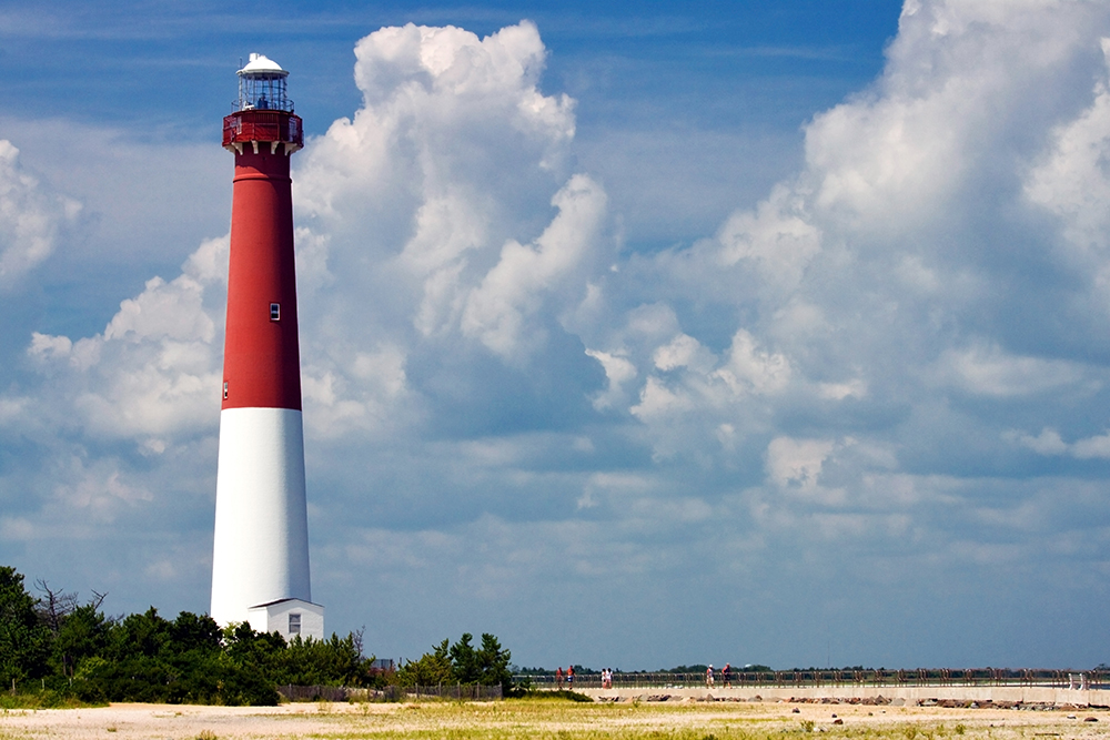


There are some names on Long Beach Island that just are. You don’t question them. You don’t Google them at the beach. You just say them — the way your parents said them, the way their parents said them before that.
Old Barney is one of those names.
The 172-foot lighthouse standing guard at the northern tip of LBI has been “Old Barney” for so long that most people assume the nickname is self-explanatory. It’s old. It’s the Barnegat Lighthouse. Old Barney. Done.
But if you pull that thread — and I mean really pull it — the story goes back further than the lighthouse itself. Further than George Meade’s tower. Further, even than the English language on this coastline.
So who is Old Barney? Let’s trace the name to the beginning.
It Starts With The Dutch
Long before anyone built a lighthouse here, Dutch explorers were charting the Jersey coastline. In 1614, Captain Cornelius Mey — the same Mey who gave Cape May its name — encountered a turbulent inlet along the barrier islands. The water churned. The shoals shifted. The currents pulled.
He described it with a Dutch term: Barndegat.
The conventional story says the original word was Barendegat, meaning “inlet of the breakers” — a reference to the violent surf crashing through the narrow channel. And for generations, that’s the version that stuck in the history books. But the etymology isn’t quite that clean.
As Keith Germain meticulously documented in his 2020 research paper The Case for Barndegat, the word “Barendegat” doesn’t actually exist in the Dutch language. The word gat does — meaning hole, gap, channel, or harbor. Germain argues that the original term was likely Barndegat, not Barendegat, and that Mey may have been describing something that reminded him of a dijkdoorbraak — a dike breach back home in the Netherlands. The swift waters of the inlet pouring into the vast bay behind it would have looked eerily familiar to a Dutch sailor who’d seen floodwaters breach the dikes of his homeland.
Robert Juet, Henry Hudson’s first mate, had described the bay just a few years earlier as “a great lake of water” composed of “drowned land.” To a Dutchman, that description would have conjured something very specific.
Whether Barndegat was a proper name or a description, the word evolved over the centuries — from Barendegat to Barndegat to Barnegat — as it passed through English-speaking mouths and onto English-made maps.
And it was on one of those English maps that “Old Barney” may have first appeared.
The Map on Charing Cross
In 1778, William Faden — the official cartographer to King George III — published The Province of New Jersey, Divided into East and West, Commonly Called the Jerseys from his shop on Charing Cross in London. It was the finest map of New Jersey produced in the 18th century, built from Bernard Ratzer’s military surveys and enriched with intelligence from British and Hessian officers during the Revolution.
Faden’s map captured extraordinary detail: every road, every river, every township. But tucked into the coastline near the inlet, he printed something cartographers hadn’t used before.
As Kent Mountford notes in Closed Sea: From the Manasquan to the Mullica, A History of Barnegat Bay, Faden “carefully printed a ‘Barigate Inlet’ opening into ‘The Sound’ which lay behind ‘Old Barnegat Beach,’ the latter term being perhaps a concession to popular usage.”
Read that again. Old Barnegat Beach. In 1778. More than eighty years before the current lighthouse was even built.
This means “Old Barnegat” wasn’t a 20th-century nickname used to rally preservationists. It wasn’t coined by a local newspaper or a tourism board. The “Old” was already attached to this stretch of coastline when the Revolution was still being fought — printed by the king’s own mapmaker, likely reflecting what locals had been calling it for years before ink ever hit paper.
From Old Barnegat to Old Barney is barely a slur of the tongue. The kind of shorthand that happens naturally when a name gets passed between fishermen and lifesavers, keepers and their families, visitors and the people who served them fried clams at the end of the island.
But The Locals Tell It Differently
Of course, not everyone on LBI learned their history from 18th-century cartography. Some learned it from a poem — and a much better story.
There’s an old piece of shore folklore that offers a decidedly more colorful explanation for the name. It goes something like this:
A jolly sailor — “a jolly, jolly tar” — spotted the lightkeeper’s daughter on the beach and chased her across the sand until he caught her. When he demanded a kiss, she squealed and called for her father. The sailor introduced himself: “Sure my name is Barney Flynn.”
The old lightkeeper wasn’t having it. He went after the sailor, who made a run for the water. And the place where Barney “gat” — as in got to — the water became “Barnegat.”
Barney gat for the water. And so the place, from near and far, was named.
Is any of it true? Probably not. But that’s never stopped a good story on this island.
Like all good shore lore, it carries a grain of emotional truth. This coastline has always been a place where land and sea collide — where people chase things and get chased, where the tide decides who stays and who goes.
And if you squint, there’s something poetic about the idea that “Old Barney” isn’t a place at all. It’s a person — a jolly, ornery, persistent character who refuses to leave.
Which brings us to the lighthouse.
When Old Barney Became A Battle Cry
Whatever the nickname’s origins, it became something more powerful in the 20th century. When the sea began swallowing the land around the lighthouse — when the Lighthouse Bureau abandoned the tower and the government refused to fund its preservation — the people of LBI didn’t rally around “Barnegat Lighthouse.”
They rallied around Old Barney.
By the 1920s, the nickname was firmly embedded in the local vocabulary. When a bill allocating $100,000 for the lighthouse’s preservation was introduced in Congress in 1924, it was “Old Barney” the newspapers wrote about. When the Lighthouse Bureau submitted an inflated cost estimate and the Department of Commerce walked away, it was “Old Barney” the community refused to let die.
Mayor Butler and the citizens of Barnegat City built an emergency jetty out of old cars, trucks, and baby carriages. By 1933, the water sat just two feet from the tower’s foundation at high tide. The federal government eventually returned to the fight in 1934, funding steel rings around the base — but only after the locals had already proven they’d sink every jalopy on the island before they’d let their lighthouse fall.
The nickname carried weight because it carried affection. “Old Barney” wasn’t a formal designation. It was the way you’d talk about a stubborn, beloved relative who’d outlived everything that tried to take him down.
The Name That Stuck
So who is Old Barney?
Old Barney is a Dutch word that lost its vowels. A stretch of beach that earned the word “Old” before the Revolution. A sailor who chased a girl across the sand. A tower that nearly fell into the sea while its neighbors built jetties out of junk cars.
Old Barney is what happens when a place gets loved long enough that formality falls away and all that’s left is the name people actually use — the one that feels like home.
The nickname didn’t come from a single moment or a single map. It accumulated, the way sand accumulates against a jetty. Layer by layer. Dutch tongues and English pens. A cartographer in London and a fisherman on the inlet. A folk poem and a preservation fight.
And now, 167 years after Meade’s tower first threw its light across the shoals, the name is so deeply embedded in the identity of Long Beach Island that the island itself is — quite literally — south of Old Barney.
See you over the bridge.
Sources & Further Reading
Kent Mountford, Closed Sea: From the Manasquan to the Mullica, A History of Barnegat Bay (Down The Shore Publishing). The William Faden map reference and “Old Barnegat Beach” citation appear in Mountford’s discussion of early cartography of the Barnegat region.
Keith A. Germain, The Case for Barndegat: A Journey from Barendegat to a Burning Hole (November 2020). A detailed etymological analysis of the Dutch origins of “Barnegat,” challenging the conventional “Barendegat” narrative.
William Faden, The Province of New Jersey, Divided into East and West, Commonly Called the Jerseys (London: Charing Cross, 1778). The landmark Revolutionary-era map of New Jersey.
Elinor DeWire, “Old Barnegat Light: What’s in a Name?” (2014). Lighthouse historian’s account of the Barney Flynn folk poem and the Dutch etymology.
Lighthousefriends.com, “Barnegat Lighthouse, New Jersey.” Detailed preservation history, including the 1920s-1930s community fight to save the tower.
Edwin Salter, A History of Monmouth and Ocean Counties (1890). Early documentation of the Barnegat name evolution.
David Gold, Studies in Etymology and Etiology (2009). Scholarly analysis of the Dutch linguistic roots of New Jersey place names.

Comments +